The science team’s annual dipwell campaign starts today – measuring water levels at monitoring sites across the Peak District and South Pennines.
Today, a team of thirty-two staff and dedicated volunteers are out checking water levels on nine different sites. A total of 840 measurements will be taken across the Peak District and South Pennines, from Kinder Scout to Turley Holes.
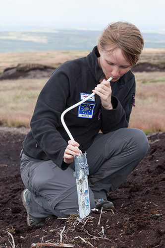
Every Thursday from now until Christmas the team will be out in all weathers, walking across the open moorland to each well.The dipwells are checked manually, by blowing down a tube which is lowered into the well. When the tube reaches water, bubbles are produced and the resulting depth is measured and recorded. This approach might seem low-tech but has proved to be the most reliable. Trials with automatic sensors have produced less accurate results, so every reading is taken in this way.
The measurements are all taken on the same day to give a snapshot of water levels across a range of sites including the MoorLIFE project and Kinder Catchment Project. From next week measurements will also be taken on Moscar Moor bringing the total number of dipwells to 900.
This work will provide invaluable information on the effect of our conservation work, which aims to ‘rewet’ the moors and provide the right conditions for plants like sphagnum - vital to peat formation in active blanket bog. Monitoring takes place on intact peat which has not been damaged by industrial pollution or wildfires, and areas of bare peat as well as areas that have undergone conservation work.
We’re also examining the effect of our work on flooding. Our Making Space for Water project has found that revegetating areas of bare peat slows the runoff from moorland following downpours. To add to this knowledge, our dipwell team includes fourteen volunteer rangers from the Peak District National Park who will be measuring water levels in 180 manual dipwells on Kinder Scout and Bleaklow and taking additional measurements to find out how rainwater flows across the surface of the moors.
Find out More:
- Making Space for Water Project
- MoorLIFE Project
- Kinder Catchment Project
- TImelapse video of storm water levels